Submarine geomorphology of the Celtic Sea continental shelf and the southern extent of glaciation on the Atlantic margin of Europe
Résumé
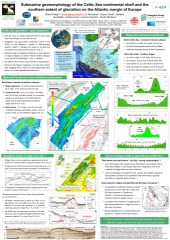
Ice sheets have occupied the Atlantic continental margin of Europe as far south as the Celtic Sea, where the maximum extent of glaciation remains in question. The Celtic Sea contains no obvious glacial landforms, but is dominated by a system of shelf-crossing seafloor megaridges, up to 60 m high and 10 km wide, that extend seaward up to 300 km in water depths of 100-200 m. The last British-Irish Ice Sheet (BIIS) was thought to have reached a limit on the mid-shelf, based on glacigenic sediments sampled on and between megaridges in the Irish-UK sectors, but recent work in this area has shown that the BIIS extended at least 150 km farther, at minimum to the UK shelf edge at 48˚20'N. Stratigraphic analysis of newly acquired core and seismic data has indicated the megaridges to be eroded sand bodies, which can be interpreted as a) glaciofluvial ridges modified by post-glacial megatides, or b) tidal banks truncated by wave energy. Here we examine megaridge morphology using a regional bathymetric grid and multibeam data across a 25x100 km area of the mid-shelf. At regional scale, the megaridges fan seaward to meet the shelf edge near-transversely along 600 km of its length, their axes rotating by 80˚ from W-E (Irish shelf) to almost N-S (French shelf). The fan-shaped network points to an apex in the north Celtic Sea, yet axial convergences are more common to seaward than landward. Individual megaridges consist of segments tens of kms long, of differing orientation, that form bathymetric highs. On the Irish-UK mid-shelf, multibeam imagery show that en echelon megaridge segments (up to 40 km long, 7 km wide, 55 m high) give way both axially and laterally to transverse 'ribs' (up to 10 km long, 10 m high). The ribs vary in form and spacing, distinct from asymmetric regularly-spaced sand waves within the multibeam data. Glacigenic sediments have been reported near seabed on and between both the megaridges and ribs, but subglacial lineations are not observed at seafloor. We hypothesise that the rectilinear network of megaridges and ribs are the eroded remnants of giant eskerine ridges flanked by glaciofluvial De Geer moraines, formed time-transgressively along an ice sheet margin during its retreat from the shelf edge. If correct, this interpretation would have broad implications for the dynamics of the last BIIS, and for the supply of meltwater and sediment across the shelf and slope to the North Atlantic at the LGM. Glaciofluvial vs tidal models for the formation of Celtic Sea bedforms invite testing through the targeted acquisition of core data, notably from areas of existing multibeam data in both the Irish-UK and French sectors.
Fichier principal
 Praeg&al_INQUA2019_poster.pdf (4.64 Mo)
Télécharger le fichier
image.png (2.41 Ko)
Télécharger le fichier
Praeg&al_INQUA2019_poster.pdf (4.64 Mo)
Télécharger le fichier
image.png (2.41 Ko)
Télécharger le fichier
Origine : Fichiers produits par l'(les) auteur(s)
Loading...