Mapping soil and substratum at a very high spatial resolution in the hillslope of Couchey (France)
Résumé
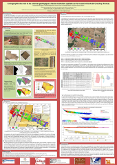
In this work, we present a method based on very high spatial resolution (VHSR) aerial images acquired in the visible domain and that map soil surface diversity at the hillslope scale with a spatial resolution of a few centimeters. This method combines aerial VHSR image classification with local soil sampling. Principal component analysis (PCA) and non-supervised classification was performed on image characteristics to define soil surface characteristic classes (SSC). Then soil surface mapping was combined with soil surface descriptions and soil profiles to define soil types by physical and chemical characteristics. As soil results from parent material alteration, identifying the geological substratum can help to explain the diversity of vineyard soils. The confrontation between soil map and geological map at a 1:10000 scale highlights a good correlation between the geological substratum and soils classes for this hillslope.
Fichier principal
 Poster_ITC_2012_Chevigny_et_al.pdf (36.52 Mo)
Télécharger le fichier
Article_ITC_2012_Chevigny_et_al (1).doc (5.47 Mo)
Télécharger le fichier
Poster_ITC_2012_Chevigny_et_al.pdf (36.52 Mo)
Télécharger le fichier
Article_ITC_2012_Chevigny_et_al (1).doc (5.47 Mo)
Télécharger le fichier
Origine : Fichiers produits par l'(les) auteur(s)
Origine : Fichiers produits par l'(les) auteur(s)
Loading...