Map of the Mariana Trench: Bathymetry. QGIS 3.0 - Archive ouverte HAL Accéder directement au contenu
Carte Année : 2018

Map of the Mariana Trench: Bathymetry. QGIS 3.0

Polina Lemenkova
Fichier principal
Vignette du fichier
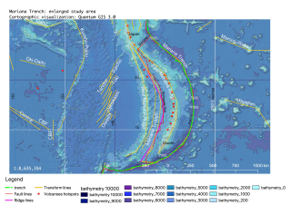
Map of the Mariana Trench Bathymetry. QGIS 3.0.pdf (887.36 Ko) Télécharger le fichier
Origine : Fichiers produits par l'(les) auteur(s)

Dates et versions

medihal-01991387 , version 1 (23-01-2019)

Licence

CC0 - Transfert dans le Domaine Public

Identifiants

  • HAL Id : medihal-01991387 , version 1

Citer

Polina Lemenkova. Map of the Mariana Trench: Bathymetry. QGIS 3.0. Qingdao, China. 2018. ⟨medihal-01991387⟩
52 Consultations
14 Téléchargements

Partager

Gmail Facebook X LinkedIn More