RouteLens: Easy Route Following for Map Applications
Abstract
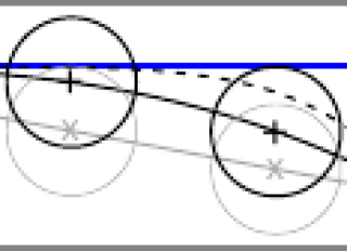
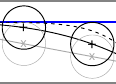
Millions of people go to the Web to search for geographical itineraries. Inspecting those map itineraries remains tedious because they seldom fit on screen, requiring much panning & zooming to see details. Focus+context techniques address this problem by displaying routes at a scale that allows them to fully fit on screen: users see the entire route at once, and perform magnified steering using a lens to navigate along the path, revealing additional detail. Navigation based on magnified steering has been shown to outperform pan & zoom for large steering tasks. Yet, this task remains challenging, in part because paths have a tendency to "slip off" the side of the lens. RouteLenses automatically adjust their position based on the geometry of the path that users steer through. RouteLenses make it easier for users to follow a route, yet do not constrain movements too strictly, leaving them free to move the lens away from the path to explore its surroundings.
Fichier principal
 AVI14-routelens-hal-v2.pdf (345.47 Ko)
Télécharger le fichier
AVI14-routelens-hal-v2.pdf (345.47 Ko)
Télécharger le fichier
 routelens-prethumb-2.png (4.91 Ko)
Télécharger le fichier
routelens-prethumb-2.png (4.91 Ko)
Télécharger le fichier
Origin : Files produced by the author(s)
Format : Figure, Image
Loading...